Currency:
The official currency tendered is the Tanzanian shilling. 1 USD transfers to approximately 2,255 Tanzanian Shillings.
Electricity:
The standard voltage is 230V/ 50Hz. The plugs used in Tanzania have three round, or rectangular, plugs. Bring a converter if you bring any electric devices such as laptops, shaving machine, I pod, etc.
Language:
There are many languages spoken in Tanzania. The official language is Swahili and English is widely spoken.
Time Zone
Eastern Africa Time (EAT) UTC +3:00
Country Information
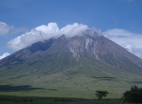
Tanzania is an East African country situated just south of the Equator. Except for the narrow coastal belt of the mainland and the offshore islands, most of mainland Tanzania lies above 600 feet in elevation. Vast stretches of plains and plateaus contrast with spectacular relief features, notably Africa’s highest mountain, Kilimanjaro (19,340 feet), and the world’s second deepest lake, Lake Tanganyika (4,710 feet deep).
The East African Rift System runs in two north-south-trending branches through mainland Tanzania, leaving many narrow, deep depressions that are often filled by lakes. Because of its numerous lakes, approximately 22,800 square miles (59,000 square km) of Tanzania’s territory consists of inland wate
Lake Victoria, which ranks as the world’s second largest freshwater lake, is not part of the Rift System. Although Tanzania has no big rivers, it forms the divide from which the three great rivers of the African continent rise—the Nile, the Congo, and the Zambezi, which flow to the Mediterranean Sea, the Atlantic Ocean, and the Indian Ocean. Separated by the central plateau, the watersheds of these rivers do not meet.
All of Tanzania’s major rivers—the Ruvuma, the Rufiji, the Wami, and the Pangani—drain into the Indian Ocean. The largest, the Rufiji River, has a drainage system that extends over most of southern mainland Tanzania. The Kagera River flows into Lake Victoria, whereas other minor rivers flow into internal basins formed by the Great Rift Valley. With so many rivers, mainland Tanzania is rich in hydroelectricity potential.
Tanzania can be divided into four principal climactic areas: the hot and humid coastal lowlands of the Indian Ocean shoreline, the hot and arid zone of the broad central plateau, the high inland mountain and lake region of the northern border, where Mount Kilimanjaro is situated, and the highlands of the northeast and southwest, the climates of which range from tropical to temperate.
Rainfall is highly seasonal. Roughly half of mainland Tanzania receives less than 30 inches of precipitation annually, an amount considered to be the minimum required for most forms of crop cultivation in the tropics. The central plateau, which receives less than 20 inches per year on average, is the driest area and experiences a single rainy season between December and May. Precipitation is heavier on the coast, where there are two peaks of precipitation: October–November and April–May. The offshore islands and many highland areas have high annual precipitation totals of more than 60 inches.